Recommended Routes: The Scottish Highlands & Islands
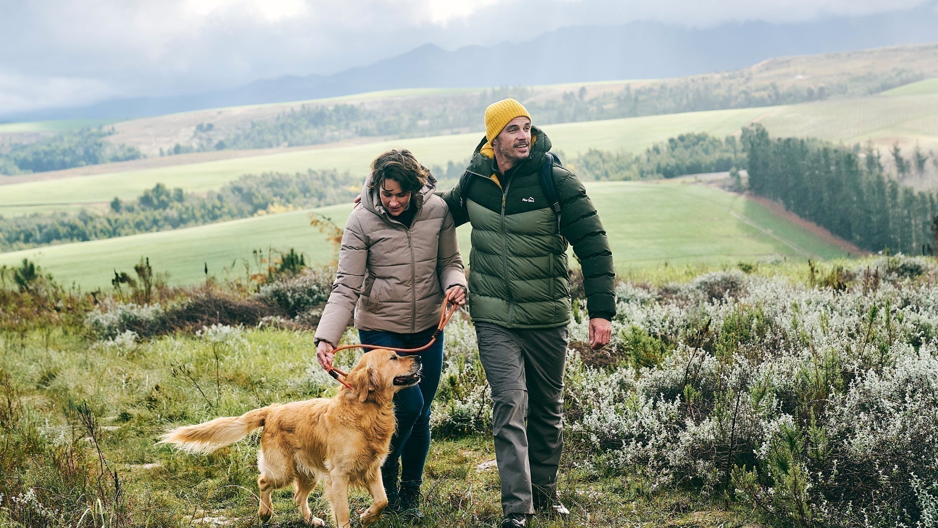
We believe there is no better way to explore Great Britain than on foot or bike. To prove that point, we’ve teamed up with Ordnance Survey, the national mapping agency, to share the best routes they recommend in Great Britain.
In this guide we lace up ready to explore the paths and trails which make The Scottish Highlands and surrounding islands a spectacular place for adventurers. We’ve split the routes into categories i.e. lake, hill, mountain, with grade levels (Easy, Moderate, Challenging, Mountain). You'll also find the Ordnance Survey map you’ll need; plus, you can explore the route virtually using the recorded ‘Fly Through Videos’. Use the Navigation below to select Lake, Hill or Mountain routes.
A Quick Guide to Exploring Britain Responsibly
- Check and follow the latest Government guidelines for England, Scotland & Wales
- Plan ahead
- Take the right gear
- If it feels too busy, consider another option
- Read our simple Guide to Map Reading with Ordnance Survey & Knowing Your Compass
Countryside
Hill
River
Mountain
Forest
Coast
Recommended Routes in The Scottish Highlands & Islands
Lace up your walking boots, pack your snacks and join us as we explore the best routes for walkers, cyclists and families in The Scottish Highlands.
Countryside
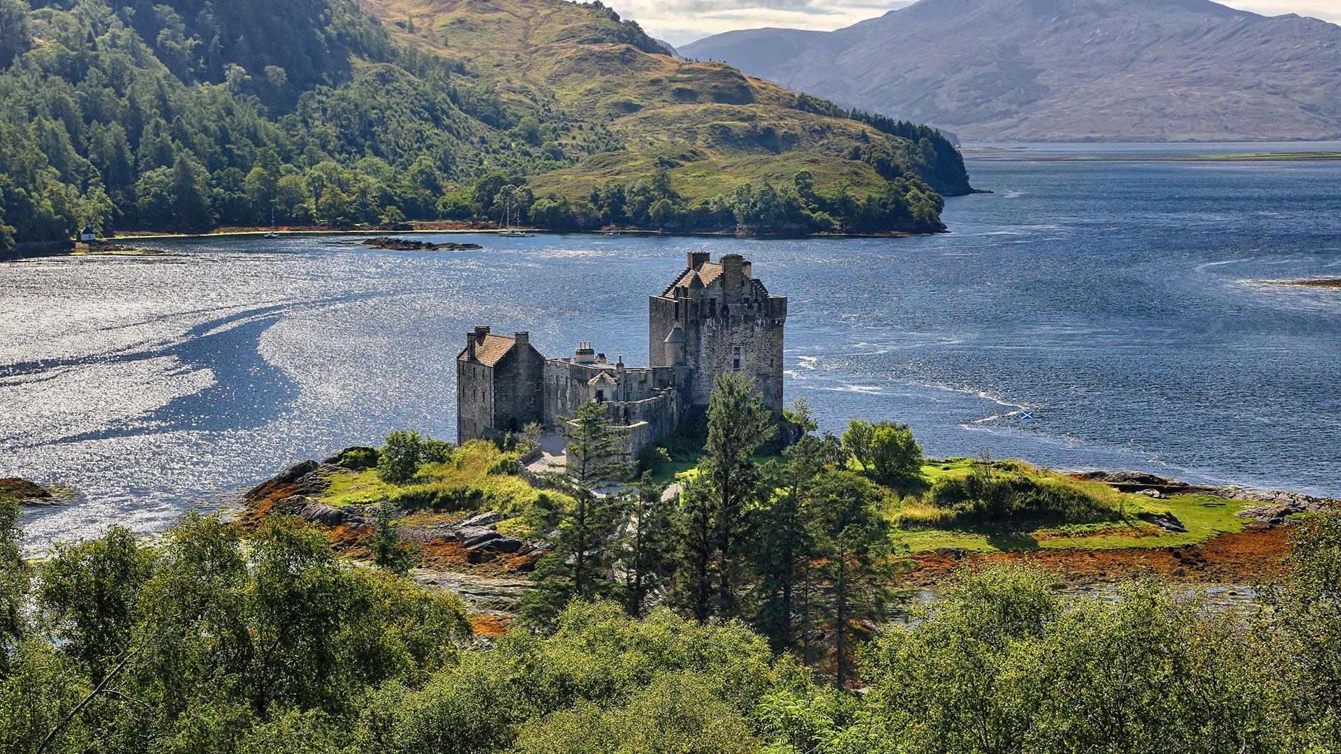
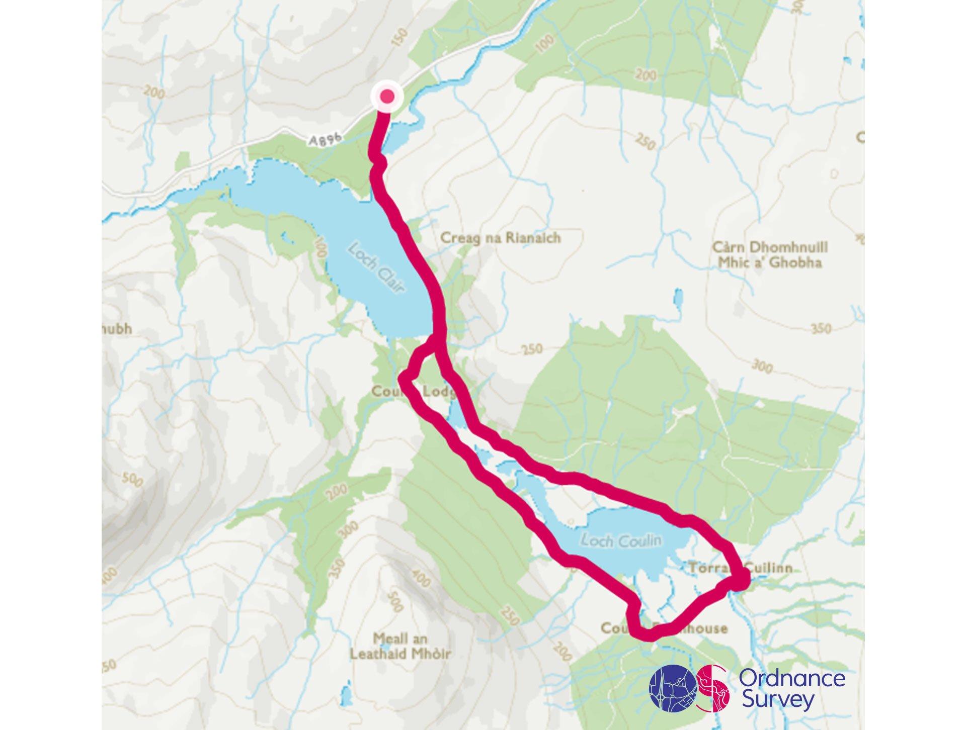
Torridon - Loch Clair & Loch Coulin
Grade: Moderate
Terrain: Countryside
Distance: 9.5km | Approx. Time: 2:07 - 2:30 hours
Ordnance Survey Map: Explorer Active 433
Ordnance Survey Digital Route Here.
This walk around Loch Clair & Coulin offers an almost-level circuit route with breath-taking views of Beinn Eighe and Liathach from across the water. Beinn Eighe and Liathach are both Munros, a Munro being a Scottish Mountain over 3,000 feet in height. The two closest settlements are Torridon village and Kinlochewe. The Torridon Hotel is a must visit, offering a selection of accommodation to suit everyone, and food from fine dining in its restaurant, to pub meals in the bar area. Torridon Outdoors which is located on the hotel grounds, offers a selection of outdoor activities for beginners to experts, from walking in the hills to Munro bagging, and mountain biking to sea kayaking. Even on short walks around the area it is possible to spot deer and pine martens, and seals and otters around the shores of Torridon village.
Falls of Foyers (Loch Ness), Invernesshire
Grade: Easy
Terrain: Countryside
Distance: 5.1km | Approx. Time: 1:24 - 1:55 hours
Ordnance Survey Digital Route Here.
This walk around Loch Clair & Coulin offers an almost-level circuit route with breath-taking views of Beinn Eighe and Liathach from across the water. Beinn Eighe and Liathach are both Munros, a Munro being a Scottish Mountain over 3,000 feet in height. The two closest settlements are Torridon village and Kinlochewe. The Torridon Hotel is a must visit, offering a selection of accommodation to suit everyone, and food from fine dining in its restaurant, to pub meals in the bar area. Torridon Outdoors which is located on the hotel grounds, offers a selection of outdoor activities for beginners to experts, from walking in the hills to Munro bagging, and mountain biking to sea kayaking. Even on short walks around the area it is possible to spot deer and pine martens, and seals and otters around the shores of Torridon village.
Hill
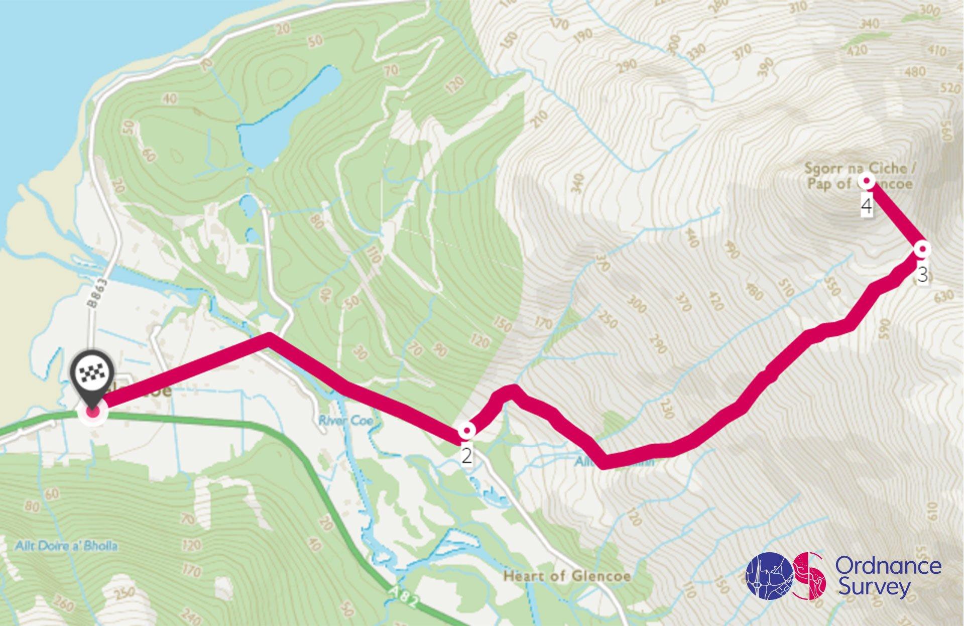
Pap of Glencoe Walk
Grade: Challenging
Terrain: Hill
Distance: 7.6 km | Approx. Time: 3:00 - 3.30 hours
Ordnance Survey Map: Explorer 384
Ordnance Survey Digital Route Here.
The Pap of Glencoe is a mountain on the northern side of Glen Coe, in the Highlands of Scotland, and locals refer to the mountain as The Pap. The Pap has distinctive conical shape, and it lies at the western end of the Aonach Eagach ridge, directly above the point where the River Coe merges with Loch Leven. The Pap provides wonderful views over the surrounding mountains and lochs. Glencoe Village is the main settlement in Glen Coe, and was one of the MacDonald clan settlements at the time of the Glencoe Massacre. From the village you can take a short walk to the monument created at Signal Rock where it is reported that the MacDonalds would light a fire to warn villagers of danger.
Glen Nevis & Steall Falls
Grade: Easy
Terrain: Valley
Distance: 5.4km | Approx. Time: 1:40 - 2:00 hours
Ordnance Survey Map: Explorer 392
Ordnance Survey Digital Route Here.
Glen Nevis is a beautiful glen located in Lochaber and is bordered to the south by the Mamore range, and to the north by the highest mountain in the British Isles, Ben Nevis. The glen is home to one of the highest waterfalls in Scotland, Steall Falls. The Glen is filled with both human and natural history. High above the Glen on a steep rising knoll is the Iron Age fort called, Dun Deardail. Fort William is the closet town to the glen and can be used an ideal base to explore the area. Fort William is also the start of the Caledonian canal which connects the town to Inverness via the famous Loch Ness. The Caledonian canal can be sailed by boat or walked/cycled following the Great Glen Way.
River
Inverness Island River Walk
Grade: Easy
Terrain: River
Distance: 5.8km | Approx. Time: 1:15 - 1:30 hours
Ordnance Survey Digital Route Here.
Inverness, in the North of Scotland, is known as Scotland’s Highland Capital. Inverness is a tourist town with many visitors starting or finishing their tour of the Northern Highlands from here. It’s also the starting point of the well-publicised North Coast 500 route. The North Coast 500 is a driving route which is 516 miles and usually attempted between 5-7 days. This Circular Walk River walk starts and finishes at the Inverness Court Building, which is a spectacular castle-like building. The route also takes in some lovely views along the River Ness and crosses the small islands in the middle of the river. You will probably spot some fishermen along the way trying to catch some salmon, as the Ness is famous for its salmon fishing.
Mountain
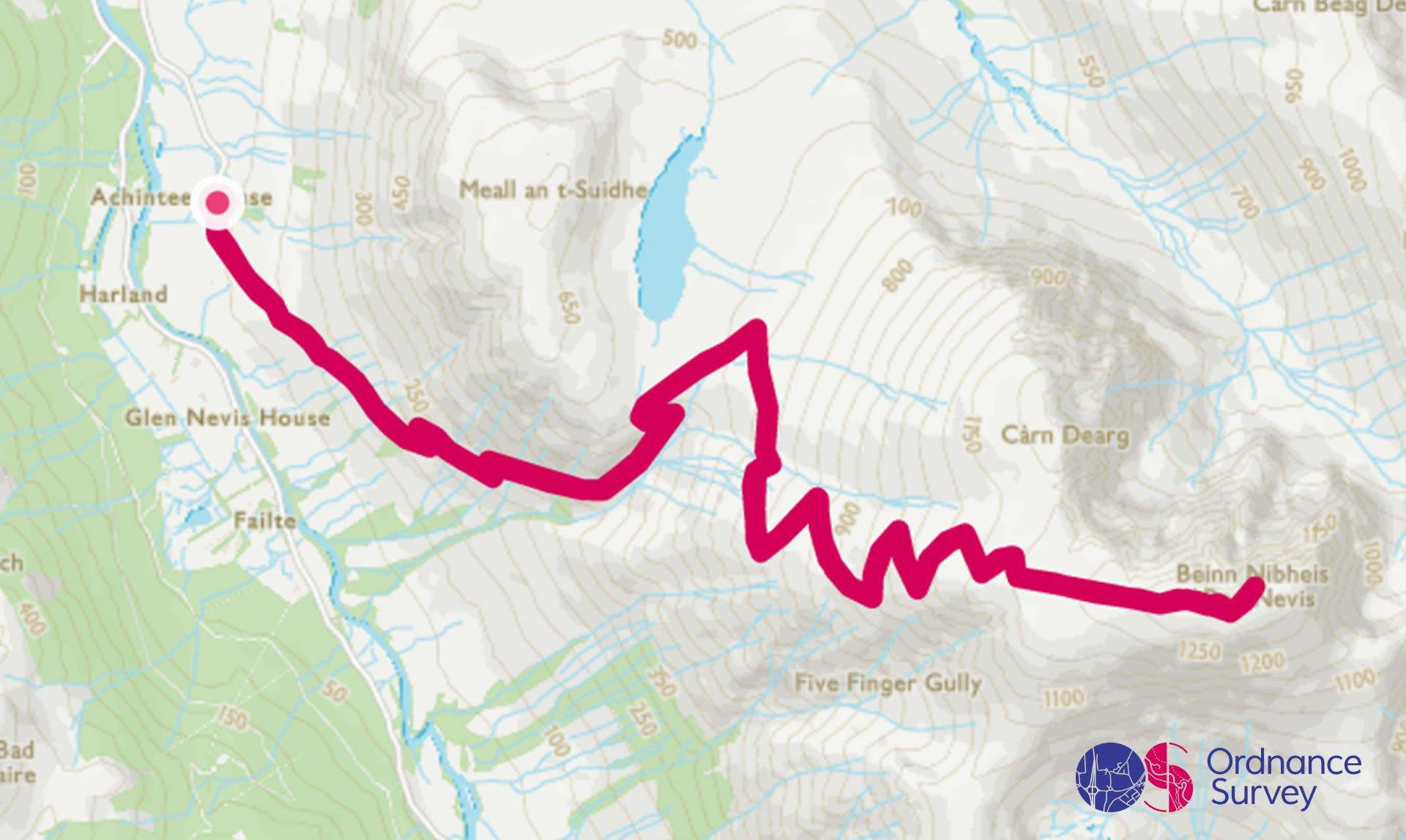
Ben Nevis
Grade: Challenging
Terrain: Mountain
Distance: 15km | Approx. Time: 5:30 - 6:30 hours
Ordnance Survey Map: Explorer 392
Ordnance Survey Digital Route Here.
Ben Nevis is the highest mountain in the British Isles and is close to the town of Fort William (also known to be the outdoor capital of the UK). The summit of Ben Nevis is a height of 1,345 metres (4,413 ft) above sea level and the Old Observatory sits at the summit, which was opened in 1883, It provided hourly meteorological data for almost 20 years and closed in 1904. Ben Nevis is a rewarding challenge and should be tackled with the appropriate kit, as the weather can change and be unpredictable on the higher ground. Nearby Nevis Range also offers mountain biking for most of the year, and skiing/snowboarding over the winter months when snow is on the slopes.
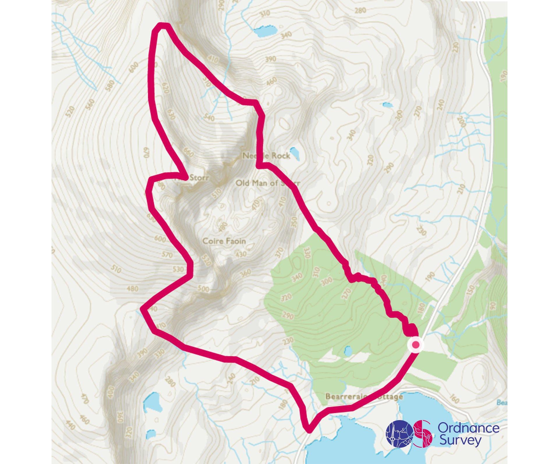
Old Man of Storr
Grade: Challenging
Terrain: Mountain
Distance: 7.7km | Approx. Time: 2:40 - 3:15 hours
Ordnance Survey Map: Explorer 408
Ordnance Survey Digital Route Here.
The Storr - the high point of the Trotternish Ridge, forming the backbone of the magnificent Isle of Skye. The glorious views from the Storr, take in much of Skye's eastern seaboard with the rolling Red Cuillin and the iconic Black Cuillin forming an incredible backdrop to this superb walk. The Old Man of Storr is a large standing formation standing at 719 meters high. 7 miles south of the Old Man of Storr is Portree, the largest town on Skye. Portee is set round its natural harbour and fringed by high ground and cliffs, the town is a popular holiday destination, and the harbour continues to be used by fishing boats. Not too far away at Brother Point, fossilised dinosaur foot prints can be found, when the tide is out and try your best to spot them.
Bones Caves, Inchnadamph
Grade: Moderate
Terrain: Mountain
Distance: 7.4km | Approx. Time: 1:50 - 2:20 hours
Ordnance Survey Digital Route Here.
Inchnadamph is in the far North Westin an area called Assynt. The nearby Bone Caves were the site of a remarkable discovery. While surveying the geology of the area, two men came across two caves filled with animal bones. We now realise that these bones are the most complete record of the last glacial period found in Scotland. Species discovered here include Arctic fox, wolf, lynx, brown bear and even Polar bear. The caves are easily accessed. If you are completing the North Coast 500 or staying in the area this is worth a visit for a walk.
The Lost Valley, Glencoe
Grade: Moderate
Terrain: Mountain
Distance: 5.3km | Approx. Time: 2:00 - 2:30 hours
Ordnance Survey Digital Route Here.
The Lost Valley of Glencoe is also known as the ‘Hidden Valley’, it sits between two of the Three Sisters of Glencoe, part of the Bidean nam Bian range on the south side of Glencoe. This was where the Glen’s resident clan, Clan Macdonald, hid their cattle from potential rustlers and used as an escape route when attacked hence the name and could not be seen from the main route of Glencoe. If you follow the road towards Glencoe village you will come across the Clachaig Inn, a fantastic pub/inn with a great choice of various Scottish fine ales and food. Also if you staying in the area for a couple of days, be sure to go check out the Ice Factor in Kinlochleven, it has a massive in built freezer for people to practise ice climbing in.
Forest
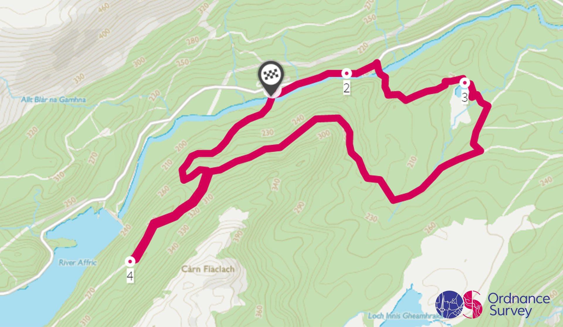
Glen Affric - Dog Falls Circular Walk
Grade: Moderate
Terrain: Forest
Distance: 6.4km | Approx. Time: 1:42 - 2:10 hours
Ordnance Survey Map: Explorer 415
Ordnance Survey Digital Route Here.
Dog Falls is a series of waterfalls on the River Affric, in Glen Affric in the Highlands of Scotland. The falls are within the Glen Affric National Nature Reserve. Glen Affric a beautiful Scottish glen, possessing great character and wilderness value. The area is home to golden eagles, deer, endangered wildcats and a large remnant of native woodland. A project run by the charity Trees for Life has planted million native trees in the glen and at other locations where the decimated Caledonian Forest – a mosaic of Scots pine, birch, rowan, aspen and juniper – stood. If you’re into photography this spot is a must for taking some outstanding shots.
Coast
Langamull Beach, Mull
Grade: Easy
Terrain: Coast
Distance: 5.2km | Approx. Time: 1:10 - 1:30 hours
Ordnance Survey Map: Explorer 374
Ordnance Survey Digital Route Here.
Langamull Beach is one of Mull's best kept secrets, a remote and stunningly beautiful spot that can only be reached on foot. To complete this route, just head back on the same approach route. Mull is the second-largest island of the Inner Hebrides, after Skye. Tobermory was originally built as a fishing port in the late 18th century and is now the main town on Mull. It is a beautiful place with brightly painted buildings along the main street to the pier, and high woodland-fringed hills surrounding the bay. The town has a good variety of shops, hotels, and other accommodation and can be used as good base to explore the island. Ben More is the highest mountain and only Munro (mountains in Scotland that reach an elevation of 3,000 feet (910 m) or more) on the Island.

The Lost Valley, Glencoe
Grade: Challenging
Terrain: Coast
Distance: 15.6km | Approx. Time: 3:30 - 4:30 hours
Ordnance Survey Digital Route Here.
Sandwood Bay is a truly beautiful beach in Sutherland, in the Highlands of Scotland. Over a mile of pure white sands are backed by sand dunes and a loch. The views out to the sea cliffs and the famous Am Buachaille sea stack are unforgettable. The beach is remarkably quiet, and is probably one of Scotland’s most photographed beaches, with various iconic pictures taken by the Scottish photographer Colin Prior. The moorland walk in to Sandwood Bay is well worth the effort and rewards you as you see the beach laid out in front of you. The closest village is Kinlochbervie, with a few local amenities.
Add the paper map detailed in the route to your collection with 40% off all Ordnance Survey maps.?
Scotland is made for adventure. So where will you explore first? Share your snaps and tag us in your adventures using #mymillets.